Positional Astronomy:
Coordinate
systems: the horizontal or "alt-az" system
The location of an object on the sky is fixed by
celestial coordinates
analogous to the terrestrial
latitude/longitude system.
There are various systems, suitable
for different purposes;
each system needs a fundamental circle
and a fixed point on it.
The simplest is the horizontal system, which
uses the horizon as its fundamental circle.
The poles of this
circle are the zenith overhead and the nadir underfoot;
these are defined by the local vertical (using a plumb-line or
similar).
Draw a vertical circle from the zenith to the
nadir through object X.
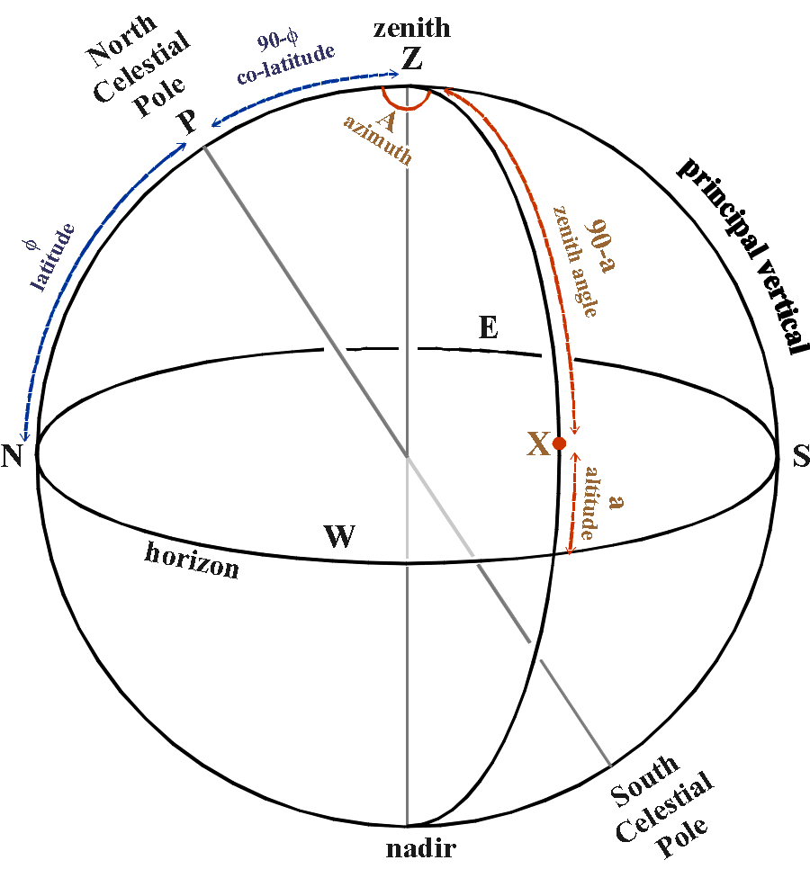 The altitude (a) of object X is the angular distance along
the vertical circle from the horizon to X,
The altitude (a) of object X is the angular distance along
the vertical circle from the horizon to X,
measured from -90°
at nadir to +90° at zenith.
Alternatively, the zenith
distance of X is 90° - a.
(Some authors use h instead of
a .)
Any two objects with the same altitude
lie on a small
circle called a parallel of altitude.
To fix a point of origin on horizon,
we look at
where the spin axis of the Earth intersects the celestial sphere,
at
the North and South Celestial Poles.
The vertical
circle through these is called the principal vertical.
Where
this intersects the horizon, it gives the north and south cardinal
points
(the north point is the one nearest the North
Celestial Pole).
Midway between these are the east and west
cardinal points;
the vertical circle through these is called the
prime vertical
(not
shown on the diagram), at 90° to the principal vertical.
The azimuth (A) of object X is the angular
distance around the horizon
from the north cardinal point to the
vertical circle through X,
measured 0°-360° westwards
(clockwise).
Note that the altitude of the North Celestial Pole
is equal to the latitude of the observer.
Comparison with the terrestrial system:
|
terrestrial
|
alt-az
|
|
equator
|
horizon
|
|
North Pole
|
zenith
|
|
South Pole
|
nadir
|
|
latitude
|
altitude
|
|
co-latitude
|
zenith distance
|
|
parallel of latitude
|
parallel of altitude
|
|
meridian of longitude
|
vertical circle
|
|
Greenwich Meridian
|
Principal Vertical
|
|
longitude
|
azimuth
|
Exercise:
From
St.Andrews, at 6 pm on 1998 February 2nd,
the Moon appeared at
altitude +39°, azimuth 196°,
while Saturn was at altitude
+34°, azimuth 210°.
How far apart did the two objects
appear?
Which was further east?
Click here for the answer.
Previous section: Spherical
trigonometry
Next section: Coordinate
systems: the first equatorial or "HA-dec" system
Return to index